Former EDGE fellow Ditto dela Rosa describes the recent work surveying marine habitats following last years earthquake.
We have just completed the underwater surveys in Danajon Bank, with the Zoological Society of London (ZSL) Philippines’ biologists – Angelie Nellas, Myrtle Arias, Hazel Panes, Edwin Dumalagan, along with their local assistants – Eduard Alivo, Darwin Bananola, Dexter Savedra and Marcelino Soccobos, and seagrass expert, Dr. Rene Rollon of the Institute of Environmental Science and Management (IESM) of the University of the Philippines, Diliman.
The team wanted to inspect the marine habitats that have been affected by the earthquake in Bohol last October 2013. The surveys could help determine the changes in coral cover and reef fish communities within these habitats. The surveys which happened from February 27 to March 11, 2014 covered eight sites: Matabao, Bilangbilangan, Cabgan, Batasan, and Canlangi in Tubigon, Asinan and Pandao in Buenavista and the Minantaw Marine Park and Sanctuary in Caubian Island, Lapu-Lapu City.
Danajon Bank is a 381.5 kilometer reef system located in northern Bohol, the only double barrier reef in the Philippines and one out of the three in the entire Southeast Asia (Pichon, 1977). It encompasses three provinces – Cebu, Bohol and Leyte, and covers a total area of 271.7 square kilometers. Since 1995, Project Seahorse has been working in Danajon Bank, empowering fishing communities to properly manage their seahorse and other marine resources. It started out as a project between Haribon Foundation and Dr. Amanda Vincent in 1997, when they decided to establish a Cebu-based, not-for-profit organization. They have been working in Bohol and other parts of Visayas since then.
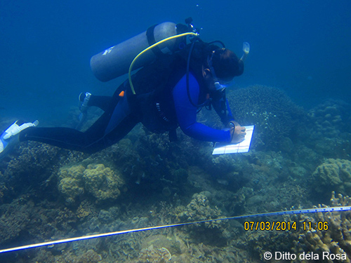
We gathered data on the cover, species, abundance and biomass in the coral reef, seagrass and mangrove communities. There, we also found out that cracks, underwater avalanche, and depression occurred. We measured the changes in the reef area using a handheld navigation device towed on a float. As an Evolutionarily Distinct and Globally Endangered (EDGE) Fellow, I looked at the presence and/or absence and abundance of the three focal EDGE Coral Reef species in Southeast Asia which are the Mushroom Coral Heliofungia actiniformis, the Pearl Bubble Coral Physogyra lichtensteini, and the Elegance Coral Catalaphyllia jardinei.

Upon arriving in Cebu and on the way to Tubigon, we discussed the methodologies we were going to use for the duration. Upon reaching Tubigon, we went directly to the office of the municipal agriculturist, so as to inform them of the activities we are going to conduct in the municipality. The group gave them the schedules of our dive survey activities. We stayed in several field bases during the operations, for ease of logistics. The Maberes Resort was our base during our surveys in Matabao, Bilangbilangan and Cabgan; Batasan Island during the surveys in their marine protected area (MPA) and Canlangi; Jandayan Island during the surveys in the Asinan MPA and Pandao; and Caubian Island during the surveys in Minantanaw Marine Park and Sanctuary.
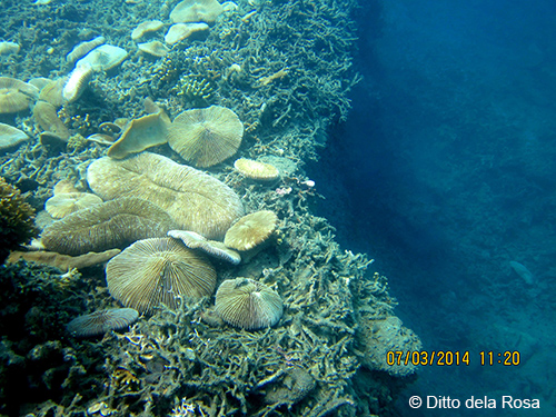
In my observations, the western part of Batasan Island, southern part of Matabao, and the Asinan MPA were the hardest areas hit by the October earthquake. Large coral heads of Porites and Lobophyllia were overturned. Sudden drop-offs have been formed on where a reef slope used to be. Networks of fissures on the reef flat were a common sight in these areas. A part of the seagrass bed in Matabao fell down at 4.5 meters in depth. We saw seahorses in broad daylight! Seahorse species in this part of the Philippines are cryptic and are characteristically nocturnal, but with most of the corals broken by the earthquake, they have been exposed. Some of the permanent transects from the previous surveys were lost, as these were mostly part of the chipped-off portions of the reef or covered by the debris and rubble. Thus, we had to establish new ones.
When we were once diving in Canlangi, I heard a strange and loud sound, like a ferry boat revving up! This was what I told my dive buddy, Hazel Panes, after our dive. I thought it was just a ferry passing by the vicinity since the shoal is adjacent to a navigation lane between Cebu and Tubigon. Heading back to Batasan Island, we were told by the residents that an earthquake actually occurred at around 2:00 PM of March 4, 2014, just about the same time we were underwater. That was it! We actually heard the sound of the earth shaking underwater.
While we left the tragic state of the reefs in Batasan, Matabao and Asinan, we rejoiced when we arrived in Minantanaw. On our first day, while assessing the area for damages, I saw a sub-adult (or teen) Humphead Wrasse (Cheilinus undulatus) and a meter-long Blacktip Reef Shark (Carcharhinus melanopterus). On our second dive, I saw all three EDGE Coral Reef species all in one site! I had a shout-out morning. On the next day, I saw an adult Humpback Grouper (Cromileptes altiveles) while snorkelling near the drop-off area.
Angie Nellas, Senior Biologist of ZSL-Philippines, told me that you would not see these species and big fishes –not to mention sharks–back when it was established. The Minantanaw Marine Park and Sanctuary was established in 2007, as a multi-use zone MPA, with funding support from Chevron Philippines, the company who markets Caltex fuels. A guardhouse or marine station was also constructed to help with the law enforcement, as well as to provide a long-run help by introducing students and tourists to marine conservation. The Minantaw Marine Park and Sanctuary Management Council manages the MPA. This is composed of representatives from the alliance of fishers in Caubian Island Nagkahiusang Mananagat sa Caubian or NAMACA and the local government of Lapu-Lapu City.
The data is currently being processed by the ZSL-Philippines team. The results of this survey will be shared during a feedback session with the local governments of the sites. It will be used by the municipal agriculturist office to inform management decisions over these marine habitats and resources.
The dive surveys could not have been possible without the hard work and laughing fits of the awesome ZSL’s team of staff and local assistants, despite the hot days, cold nights, and laughing fits. We hardly ever felt tired after four dives in a day. It helps that you enjoy the company and the purposeful work!
This blog has been reproduced with permission from its original author. The original post is available at Https://www.haribon.org.ph/index.php/news-and-media/317-reefs-after-the-earthquake-a-snapshot-of-the-danajon-bank